Navigator III Owner’s Manual
traffic inforMation
traffic inforMation
Using an optional FM TMC (Trafc Message
Channel) trafc receiver, you can view trafc
on your Navigator III. For more information
about the FM trafc receiver, participating
FM trafc subscription providers, and covered
cities, refer to www.garmin.com/trafc.
NOTE: Garmin is not responsible for
the accuracy of the trafc information.
The trafc receiver simply receives
signals from the trafc service provider
and displays that information on your
Navigator III.
Connecting the FM Trafc
Receiver
Plug the FM trafc receiver’s cable into
the mini-USB connector on the back of the
Navigator III under the weather cap.
Trafc in Your Area
From the Main menu, touch Tools > Trafc.
Touch an item to view details. Touch Near to
view trafc at a different location.
Trafc on Your Route
The map displays or when there is a
trafc delay on your route. The number in the
icon represents the delay time in minutes. The
delay time is automatically calculated into the
arrival time shown on the map. Touch or
to view more information.
Trafc Map—displays the trafc incident on
your current route.
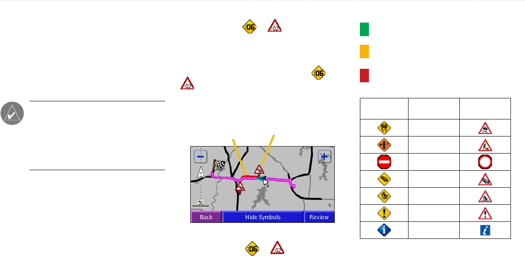
Color
code
Trafc symbol
To avoid trafc on your route:
On the map, touch or > trafc incident
> Detour Around. See page 23 for trafc
settings.
Trafc Codes and Symbols
Green = Low severity; trafc is owing
normally.
Yellow = Medium severity; trafc is a bit
congested.
Red = High severity; trafc is heavily
congested or stopped.
North
American
Meaning International
Road condition
Road
construction
Road closed
Slow trafc
Accident
Incident
Information
Adding a Subscription
Touch Settings > Trafc > Subscriptions
> Add Subscriptions. Follow the on-screen
instructions.