14
Using the Measure Distance Feature
The Measure Distance feature enables you to measure the
distance from your current position to a specied destination.
To enable the measure distance function:
1. On the map page, press the Menu button, select Measure
Dist On and press OK. A ruler appears at the cursor point on
the map screen (Fig. 27). Use the navigation keys to move to
your destination and press OK.
2. The distance between the start point and end point is
displayed.
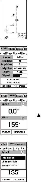
Viewing Trip Status
To view trip information such as your speed, direction, trip
time, and so on:
1. From the map page, press the Page button to view the
trip status information.
2. Use the navigation keys to toggle between the 6 elds
(Fig. 28) and 2 elds (Fig. 29) tab views, and choose the
information you want to see:
Speed: shows the speed at which you are traveling
Heading: shows the tracking direction
TripOdom: shows the distance traveled so far
TripTime: shows the time elapsed
Alt
GPS
: shows the altitude of your current location
Signal: shows the current signal strength of the device
NOTE:
The icon at the top of the trip status page indicates the location
whose information is being displayed on the map in navigation
mode. The icon cannot be selected or modied.
Resetting Trip Data
Resetting trip data will reset the value of Trip Odom and Trip
Time to zero.
To set the trip data and display new data:
Menu button, select Trip
Reset, and press OK to conrm (Fig. 30). The trip status data
is reset to default settings.
Changing the Fields
You can specify the items to be displayed in the trip status
elds.
To change the eld items:
1. On the trip status page, press the Menu button, highlight
Change Field, and press OK (Fig. 31). Select the eld you
Fig. 27
Fig. 28
Fig. 29
Fig. 30